
Static Map Catalogue - Product List
back to previous node |
list of download URLs
Collection ALOS_Africa_AVNIR2
ALOS AVNIR-2 African Coverage ESA archive. More information can be found on this page.
List of available products (latitude from 14.337 to 15.2333 dg, longitude from 28.8708 to 29.8792 dg)..
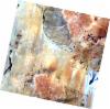
AL1_OPER_AV2_OBS_11_20080108T084134_20080108T084144_010419_0265_3300_0000
Download Product | Browse
wrsLongitudeGrid | 265 |
wrsLatitudeGrid | 3300 |
beginAcquisition | 2008-01-08T08:41:34.017Z |
endAcquisition | 2008-01-08T08:41:44.377Z |
productType | AV2_OBS_11 |
instrumentShortName | AVNIR-2 |
operationalMode | OBS |
orbitNumber | 10419 |
orbitDirection | DESCENDING |
sceneCentre | 14.944 28.959 |
acquisitionStation | SGS |
cloudCoverPercentage | 0 |
sceneId | AV2A104193300 |
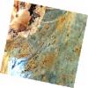
AL1_OPER_AV2_OBS_11_20080323T083825_20080323T083836_011513_0264_3300_0000
Download Product | Browse
wrsLongitudeGrid | 264 |
wrsLatitudeGrid | 3300 |
beginAcquisition | 2008-03-23T08:38:25.998Z |
endAcquisition | 2008-03-23T08:38:36.358Z |
productType | AV2_OBS_11 |
instrumentShortName | AVNIR-2 |
operationalMode | OBS |
orbitNumber | 11513 |
orbitDirection | DESCENDING |
sceneCentre | 14.944 29.487 |
acquisitionStation | SGS |
cloudCoverPercentage | 0 |
sceneId | AV2A115133300 |
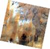
AL1_OPER_AV2_OBS_11_20080923T083827_20080923T083837_014197_0264_3310_0000
Download Product | Browse
wrsLongitudeGrid | 264 |
wrsLatitudeGrid | 3310 |
beginAcquisition | 2008-09-23T08:38:27.247Z |
endAcquisition | 2008-09-23T08:38:37.607Z |
productType | AV2_OBS_11 |
instrumentShortName | AVNIR-2 |
operationalMode | OBS |
orbitNumber | 14197 |
orbitDirection | DESCENDING |
sceneCentre | 14.444 29.403 |
acquisitionStation | SGS |
cloudCoverPercentage | 0 |
sceneId | AV2A141973310 |