
Static Map Catalogue - Product List
back to previous node |
list of download URLs

Collection ALOS_Africa_AVNIR2
ALOS AVNIR-2 African Coverage ESA archive. More information can be found on this page.
List of available products (latitude from 14.337 to 15.2333 dg, longitude from 25.1125 to 26.1208 dg)..
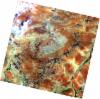
AL1_OPER_AV2_OBS_11_20070804T085737_20070804T085748_008129_0272_3300_0000
Download Product | Browse
wrsLongitudeGrid | 272 |
wrsLatitudeGrid | 3300 |
beginAcquisition | 2007-08-04T08:57:37.906Z |
endAcquisition | 2007-08-04T08:57:48.266Z |
productType | AV2_OBS_11 |
instrumentShortName | AVNIR-2 |
operationalMode | OBS |
orbitNumber | 8129 |
orbitDirection | DESCENDING |
sceneCentre | 14.944 25.210 |
acquisitionStation | SGS |
cloudCoverPercentage | 0 |
sceneId | AV2A081293300 |
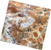
AL1_OPER_AV2_OBS_11_20080204T085616_20080204T085626_010813_0272_3300_0000
Download Product | Browse
wrsLongitudeGrid | 272 |
wrsLatitudeGrid | 3300 |
beginAcquisition | 2008-02-04T08:56:16.265Z |
endAcquisition | 2008-02-04T08:56:26.625Z |
productType | AV2_OBS_11 |
instrumentShortName | AVNIR-2 |
operationalMode | OBS |
orbitNumber | 10813 |
orbitDirection | DESCENDING |
sceneCentre | 14.945 25.204 |
acquisitionStation | SGS |
cloudCoverPercentage | 0 |
sceneId | AV2A108133300 |
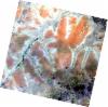
AL1_OPER_AV2_OBS_11_20080904T085258_20080904T085308_013920_0271_3300_0000
Download Product | Browse
wrsLongitudeGrid | 271 |
wrsLatitudeGrid | 3300 |
beginAcquisition | 2008-09-04T08:52:58.424Z |
endAcquisition | 2008-09-04T08:53:08.784Z |
productType | AV2_OBS_11 |
instrumentShortName | AVNIR-2 |
operationalMode | OBS |
orbitNumber | 13920 |
orbitDirection | DESCENDING |
sceneCentre | 14.942 25.754 |
acquisitionStation | SGS |
cloudCoverPercentage | 0 |
sceneId | AV2A139203300 |
AL1_OPER_AV2_OBS_11_20080904T085306_20080904T085317_013920_0271_3310_0000
Download Product | Browse
wrsLongitudeGrid | 271 |
wrsLatitudeGrid | 3310 |
beginAcquisition | 2008-09-04T08:53:06.645Z |
endAcquisition | 2008-09-04T08:53:17.005Z |
productType | AV2_OBS_11 |
instrumentShortName | AVNIR-2 |
operationalMode | OBS |
orbitNumber | 13920 |
orbitDirection | DESCENDING |
sceneCentre | 14.445 25.643 |
acquisitionStation | SGS |
cloudCoverPercentage | 0 |
sceneId | AV2A139203310 |