
Static Map Catalogue - Product List
back to previous node |
list of download URLs
Collection ALOS_Africa_AVNIR2
ALOS AVNIR-2 African Coverage ESA archive. More information can be found on this page.
List of available products (latitude from -4.34444 to -3.44815 dg, longitude from 26.1208 to 27.1292 dg)..
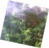
AL1_OPER_AV2_OBS_11_20080404T083859_20080404T083909_011688_0262_3670_0000
Download Product | Browse
wrsLongitudeGrid | 262 |
wrsLatitudeGrid | 3670 |
beginAcquisition | 2008-04-04T08:38:59.190Z |
endAcquisition | 2008-04-04T08:39:09.550Z |
productType | AV2_OBS_11 |
instrumentShortName | AVNIR-2 |
operationalMode | OBS |
orbitNumber | 11688 |
orbitDirection | DESCENDING |
sceneCentre | -3.484 26.628 |
acquisitionStation | SGS |
cloudCoverPercentage | 0 |
sceneId | AV2A116883670 |
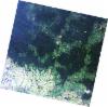
AL1_OPER_AV2_OBS_11_20080404T083907_20080404T083917_011688_0262_3680_0000
Download Product | Browse
wrsLongitudeGrid | 262 |
wrsLatitudeGrid | 3680 |
beginAcquisition | 2008-04-04T08:39:07.417Z |
endAcquisition | 2008-04-04T08:39:17.777Z |
productType | AV2_OBS_11 |
instrumentShortName | AVNIR-2 |
operationalMode | OBS |
orbitNumber | 11688 |
orbitDirection | DESCENDING |
sceneCentre | -3.983 26.522 |
acquisitionStation | SGS |
cloudCoverPercentage | 0 |
sceneId | AV2A116883680 |