
Static Map Catalogue - Product List
back to previous node |
list of download URLs
Collection ALOS_Africa_AVNIR2
ALOS AVNIR-2 African Coverage ESA archive. More information can be found on this page.
List of available products (latitude from -4.34444 to -3.44815 dg, longitude from 15.1208 to 16.1292 dg)..
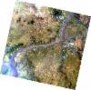
AL1_OPER_AV2_OBS_11_20080907T092150_20080907T092201_013964_0282_3680_0000
Download Product | Browse
wrsLongitudeGrid | 282 |
wrsLatitudeGrid | 3680 |
beginAcquisition | 2008-09-07T09:21:50.695Z |
endAcquisition | 2008-09-07T09:22:01.055Z |
productType | AV2_OBS_11 |
instrumentShortName | AVNIR-2 |
operationalMode | OBS |
orbitNumber | 13964 |
orbitDirection | DESCENDING |
sceneCentre | -3.982 15.782 |
acquisitionStation | SGS |
cloudCoverPercentage | 0 |
sceneId | AV2A139643680 |