
Static Map Catalogue - Product List
back to previous node |
list of download URLs
Collection ALOS_Africa_AVNIR2
ALOS AVNIR-2 African Coverage ESA archive. More information can be found on this page.
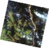
List of available products (latitude from -4.9963 to -4.1 dg, longitude from 20.6208 to 21.6292 dg)..
AL1_OPER_AV2_OBS_11_20080921T090055_20080921T090106_014168_0272_3700_0000
Download Product | Browse
wrsLongitudeGrid | 272 |
wrsLatitudeGrid | 3700 |
beginAcquisition | 2008-09-21T09:00:55.758Z |
endAcquisition | 2008-09-21T09:01:06.118Z |
productType | AV2_OBS_11 |
instrumentShortName | AVNIR-2 |
operationalMode | OBS |
orbitNumber | 14168 |
orbitDirection | DESCENDING |
sceneCentre | -4.978 20.939 |
acquisitionStation | SGS |
cloudCoverPercentage | 0 |
sceneId | AV2A141683700 |