
Static Map Catalogue - Product List
back to previous node |
list of download URLs

Collection ALOS_Africa_AVNIR2
ALOS AVNIR-2 African Coverage ESA archive. More information can be found on this page.
List of available products (latitude from -4.9963 to -4.1 dg, longitude from 14.1125 to 15.1208 dg)..
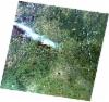
AL1_OPER_AV2_OBS_11_20070322T092651_20070322T092701_006160_0283_3700_0000
Download Product | Browse
wrsLongitudeGrid | 283 |
wrsLatitudeGrid | 3700 |
beginAcquisition | 2007-03-22T09:26:51.129Z |
endAcquisition | 2007-03-22T09:27:01.489Z |
productType | AV2_OBS_11 |
instrumentShortName | AVNIR-2 |
operationalMode | OBS |
orbitNumber | 6160 |
orbitDirection | DESCENDING |
sceneCentre | -4.979 15.039 |
acquisitionStation | SGS |
cloudCoverPercentage | 0 |
sceneId | AV2A061603700 |
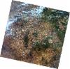
AL1_OPER_AV2_OBS_11_20080711T092522_20080711T092532_013118_0284_3690_0000
Download Product | Browse
wrsLongitudeGrid | 284 |
wrsLatitudeGrid | 3690 |
beginAcquisition | 2008-07-11T09:25:22.198Z |
endAcquisition | 2008-07-11T09:25:32.558Z |
productType | AV2_OBS_11 |
instrumentShortName | AVNIR-2 |
operationalMode | OBS |
orbitNumber | 13118 |
orbitDirection | DESCENDING |
sceneCentre | -4.480 14.608 |
acquisitionStation | SGS |
cloudCoverPercentage | 0 |
sceneId | AV2A131183690 |
AL1_OPER_AV2_OBS_11_20080711T092530_20080711T092540_013118_0284_3700_0000
Download Product | Browse
wrsLongitudeGrid | 284 |
wrsLatitudeGrid | 3700 |
beginAcquisition | 2008-07-11T09:25:30.425Z |
endAcquisition | 2008-07-11T09:25:40.785Z |
productType | AV2_OBS_11 |
instrumentShortName | AVNIR-2 |
operationalMode | OBS |
orbitNumber | 13118 |
orbitDirection | DESCENDING |
sceneCentre | -4.978 14.502 |
acquisitionStation | SGS |
cloudCoverPercentage | 0 |
sceneId | AV2A131183700 |