
Static Map Catalogue - Product List
back to previous node |
list of download URLs
Collection ALOS_Africa_AVNIR2
ALOS AVNIR-2 African Coverage ESA archive. More information can be found on this page.
List of available products (latitude from -6.78889 to -5.89259 dg, longitude from 28.8708 to 29.8792 dg)..
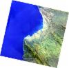
AL1_OPER_AV2_OBS_11_20080608T082329_20080608T082339_012636_0255_3720_0000
Download Product | Browse
wrsLongitudeGrid | 255 |
wrsLatitudeGrid | 3720 |
beginAcquisition | 2008-06-08T08:23:29.161Z |
endAcquisition | 2008-06-08T08:23:39.521Z |
productType | AV2_OBS_11 |
instrumentShortName | AVNIR-2 |
operationalMode | OBS |
orbitNumber | 12636 |
orbitDirection | DESCENDING |
sceneCentre | -5.975 29.857 |
acquisitionStation | SGS |
cloudCoverPercentage | 0 |
sceneId | AV2A126363720 |
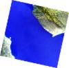
AL1_OPER_AV2_OBS_11_20080608T082337_20080608T082347_012636_0255_3730_0000
Download Product | Browse
wrsLongitudeGrid | 255 |
wrsLatitudeGrid | 3730 |
beginAcquisition | 2008-06-08T08:23:37.388Z |
endAcquisition | 2008-06-08T08:23:47.748Z |
productType | AV2_OBS_11 |
instrumentShortName | AVNIR-2 |
operationalMode | OBS |
orbitNumber | 12636 |
orbitDirection | DESCENDING |
sceneCentre | -6.473 29.751 |
acquisitionStation | SGS |
cloudCoverPercentage | 0 |
sceneId | AV2A126363730 |
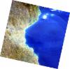
AL1_OPER_AV2_OBS_11_20080810T082559_20080810T082610_013555_0256_3720_0000
Download Product | Browse
wrsLongitudeGrid | 256 |
wrsLatitudeGrid | 3720 |
beginAcquisition | 2008-08-10T08:25:59.990Z |
endAcquisition | 2008-08-10T08:26:10.350Z |
productType | AV2_OBS_11 |
instrumentShortName | AVNIR-2 |
operationalMode | OBS |
orbitNumber | 13555 |
orbitDirection | DESCENDING |
sceneCentre | -5.972 29.304 |
acquisitionStation | SGS |
cloudCoverPercentage | 0 |
sceneId | AV2A135553720 |
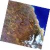
AL1_OPER_AV2_OBS_11_20080810T082608_20080810T082618_013555_0256_3730_0000
Download Product | Browse
wrsLongitudeGrid | 256 |
wrsLatitudeGrid | 3730 |
beginAcquisition | 2008-08-10T08:26:08.218Z |
endAcquisition | 2008-08-10T08:26:18.578Z |
productType | AV2_OBS_11 |
instrumentShortName | AVNIR-2 |
operationalMode | OBS |
orbitNumber | 13555 |
orbitDirection | DESCENDING |
sceneCentre | -6.470 29.198 |
acquisitionStation | SGS |
cloudCoverPercentage | 0 |
sceneId | AV2A135553730 |