
Static Map Catalogue - Product List
back to previous node |
list of download URLs

Collection ALOS_Africa_AVNIR2
ALOS AVNIR-2 African Coverage ESA archive. More information can be found on this page.
List of available products (latitude from -7.44074 to -6.54444 dg, longitude from 28.8708 to 29.8792 dg)..
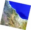
AL1_OPER_AV2_OBS_11_20070808T082918_20070808T082929_008187_0256_3740_0000
Download Product | Browse
wrsLongitudeGrid | 256 |
wrsLatitudeGrid | 3740 |
beginAcquisition | 2007-08-08T08:29:18.816Z |
endAcquisition | 2007-08-08T08:29:29.176Z |
productType | AV2_OBS_11 |
instrumentShortName | AVNIR-2 |
operationalMode | OBS |
orbitNumber | 8187 |
orbitDirection | DESCENDING |
sceneCentre | -6.972 29.101 |
acquisitionStation | SGS |
cloudCoverPercentage | 0 |
sceneId | AV2A081873740 |
AL1_OPER_AV2_OBS_11_20080608T082345_20080608T082355_012636_0255_3740_0000
Download Product | Browse
wrsLongitudeGrid | 255 |
wrsLatitudeGrid | 3740 |
beginAcquisition | 2008-06-08T08:23:45.615Z |
endAcquisition | 2008-06-08T08:23:55.975Z |
productType | AV2_OBS_11 |
instrumentShortName | AVNIR-2 |
operationalMode | OBS |
orbitNumber | 12636 |
orbitDirection | DESCENDING |
sceneCentre | -6.972 29.645 |
acquisitionStation | SGS |
cloudCoverPercentage | 0 |
sceneId | AV2A126363740 |