
Static Map Catalogue - Product List
back to previous node |
list of download URLs

Collection ALOS_Africa_AVNIR2
ALOS AVNIR-2 African Coverage ESA archive. More information can be found on this page.
List of available products (latitude from -9.23333 to -8.33704 dg, longitude from 29.1125 to 30.1208 dg)..
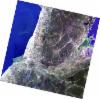
AL1_OPER_AV2_OBS_11_20080608T082418_20080608T082428_012636_0255_3780_0000
Download Product | Browse
wrsLongitudeGrid | 255 |
wrsLatitudeGrid | 3780 |
beginAcquisition | 2008-06-08T08:24:18.526Z |
endAcquisition | 2008-06-08T08:24:28.886Z |
productType | AV2_OBS_11 |
instrumentShortName | AVNIR-2 |
operationalMode | OBS |
orbitNumber | 12636 |
orbitDirection | DESCENDING |
sceneCentre | -8.964 29.219 |
acquisitionStation | SGS |
cloudCoverPercentage | 0 |
sceneId | AV2A126363780 |
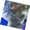
AL1_OPER_AV2_OBS_11_20080608T082410_20080608T082420_012636_0255_3770_0000
Download Product | Browse
wrsLongitudeGrid | 255 |
wrsLatitudeGrid | 3770 |
beginAcquisition | 2008-06-08T08:24:10.297Z |
endAcquisition | 2008-06-08T08:24:20.657Z |
productType | AV2_OBS_11 |
instrumentShortName | AVNIR-2 |
operationalMode | OBS |
orbitNumber | 12636 |
orbitDirection | DESCENDING |
sceneCentre | -8.466 29.326 |
acquisitionStation | SGS |
cloudCoverPercentage | 0 |
sceneId | AV2A126363770 |
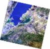
AL1_OPER_AV2_OBS_11_20080707T082204_20080707T082214_013059_0254_3770_0000
Download Product | Browse
wrsLongitudeGrid | 254 |
wrsLatitudeGrid | 3770 |
beginAcquisition | 2008-07-07T08:22:04.316Z |
endAcquisition | 2008-07-07T08:22:14.676Z |
productType | AV2_OBS_11 |
instrumentShortName | AVNIR-2 |
operationalMode | OBS |
orbitNumber | 13059 |
orbitDirection | DESCENDING |
sceneCentre | -8.466 29.852 |
acquisitionStation | SGS |
cloudCoverPercentage | 0 |
sceneId | AV2A130593770 |
AL1_OPER_AV2_OBS_11_20080707T082212_20080707T082222_013059_0254_3780_0000
Download Product | Browse
wrsLongitudeGrid | 254 |
wrsLatitudeGrid | 3780 |
beginAcquisition | 2008-07-07T08:22:12.545Z |
endAcquisition | 2008-07-07T08:22:22.905Z |
productType | AV2_OBS_11 |
instrumentShortName | AVNIR-2 |
operationalMode | OBS |
orbitNumber | 13059 |
orbitDirection | DESCENDING |
sceneCentre | -8.963 29.746 |
acquisitionStation | SGS |
cloudCoverPercentage | 0 |
sceneId | AV2A130593780 |