
Static Map Catalogue - Product List
back to previous node |
list of download URLs
Collection ALOS_Africa_AVNIR2
ALOS AVNIR-2 African Coverage ESA archive. More information can be found on this page.
List of available products (latitude from -10.7815 to -9.88519 dg, longitude from 28.8708 to 29.8792 dg)..
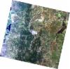
AL1_OPER_AV2_OBS_11_20080608T082434_20080608T082445_012636_0255_3800_0000
Download Product | Browse
wrsLongitudeGrid | 255 |
wrsLatitudeGrid | 3800 |
beginAcquisition | 2008-06-08T08:24:34.982Z |
endAcquisition | 2008-06-08T08:24:45.342Z |
productType | AV2_OBS_11 |
instrumentShortName | AVNIR-2 |
operationalMode | OBS |
orbitNumber | 12636 |
orbitDirection | DESCENDING |
sceneCentre | -9.961 29.005 |
acquisitionStation | SGS |
cloudCoverPercentage | 0 |
sceneId | AV2A126363800 |
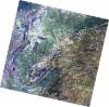
AL1_OPER_AV2_OBS_11_20080707T082229_20080707T082239_013059_0254_3800_0000
Download Product | Browse
wrsLongitudeGrid | 254 |
wrsLatitudeGrid | 3800 |
beginAcquisition | 2008-07-07T08:22:29.002Z |
endAcquisition | 2008-07-07T08:22:39.362Z |
productType | AV2_OBS_11 |
instrumentShortName | AVNIR-2 |
operationalMode | OBS |
orbitNumber | 13059 |
orbitDirection | DESCENDING |
sceneCentre | -9.959 29.531 |
acquisitionStation | SGS |
cloudCoverPercentage | 0 |
sceneId | AV2A130593800 |