
Static Map Catalogue - Product List
back to previous node |
list of download URLs
Collection ALOS_Africa_AVNIR2
ALOS AVNIR-2 African Coverage ESA archive. More information can be found on this page.
List of available products (latitude from -11.6778 to -10.7815 dg, longitude from 28.8708 to 29.8792 dg)..
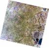
AL1_OPER_AV2_OBS_11_20060817T082428_20060817T082438_002994_0254_3820_0000
Download Product | Browse
wrsLongitudeGrid | 254 |
wrsLatitudeGrid | 3820 |
beginAcquisition | 2006-08-17T08:24:28.020Z |
endAcquisition | 2006-08-17T08:24:38.380Z |
productType | AV2_OBS_11 |
instrumentShortName | AVNIR-2 |
operationalMode | OBS |
orbitNumber | 2994 |
orbitDirection | DESCENDING |
sceneCentre | -10.955 29.322 |
acquisitionStation | SGS |
cloudCoverPercentage | 0 |
sceneId | AV2A029943820 |
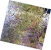
AL1_OPER_AV2_OBS_11_20060817T082436_20060817T082446_002994_0254_3830_0000
Download Product | Browse
wrsLongitudeGrid | 254 |
wrsLatitudeGrid | 3830 |
beginAcquisition | 2006-08-17T08:24:36.248Z |
endAcquisition | 2006-08-17T08:24:46.608Z |
productType | AV2_OBS_11 |
instrumentShortName | AVNIR-2 |
operationalMode | OBS |
orbitNumber | 2994 |
orbitDirection | DESCENDING |
sceneCentre | -11.452 29.214 |
acquisitionStation | SGS |
cloudCoverPercentage | 0 |
sceneId | AV2A029943830 |