
Static Map Catalogue - Product List
back to previous node |
list of download URLs
Collection ALOS_Africa_AVNIR2
ALOS AVNIR-2 African Coverage ESA archive. More information can be found on this page.
List of available products (latitude from -11.6778 to -10.7815 dg, longitude from 18.8792 to 19.8875 dg)..
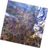
AL1_OPER_AV2_OBS_11_20080823T090409_20080823T090419_013745_0273_3820_0000
Download Product | Browse
wrsLongitudeGrid | 273 |
wrsLatitudeGrid | 3820 |
beginAcquisition | 2008-08-23T09:04:09.081Z |
endAcquisition | 2008-08-23T09:04:19.441Z |
productType | AV2_OBS_11 |
instrumentShortName | AVNIR-2 |
operationalMode | OBS |
orbitNumber | 13745 |
orbitDirection | DESCENDING |
sceneCentre | -10.954 19.106 |
acquisitionStation | SGS |
cloudCoverPercentage | 0 |
sceneId | AV2A137453820 |
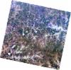
AL1_OPER_AV2_OBS_11_20080823T090417_20080823T090427_013745_0273_3830_0000
Download Product | Browse
wrsLongitudeGrid | 273 |
wrsLatitudeGrid | 3830 |
beginAcquisition | 2008-08-23T09:04:17.311Z |
endAcquisition | 2008-08-23T09:04:27.671Z |
productType | AV2_OBS_11 |
instrumentShortName | AVNIR-2 |
operationalMode | OBS |
orbitNumber | 13745 |
orbitDirection | DESCENDING |
sceneCentre | -11.451 18.998 |
acquisitionStation | SGS |
cloudCoverPercentage | 0 |
sceneId | AV2A137453830 |