
Static Map Catalogue - Product List
back to previous node |
list of download URLs
Collection ALOS_Africa_AVNIR2
ALOS AVNIR-2 African Coverage ESA archive. More information can be found on this page.
List of available products (latitude from -15.2333 to -14.337 dg, longitude from 16.1292 to 17.1375 dg)..
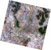
AL1_OPER_AV2_OBS_11_20080828T091139_20080828T091149_013818_0276_3890_0000
Download Product | Browse
wrsLongitudeGrid | 276 |
wrsLatitudeGrid | 3890 |
beginAcquisition | 2008-08-28T09:11:39.249Z |
endAcquisition | 2008-08-28T09:11:49.609Z |
productType | AV2_OBS_11 |
instrumentShortName | AVNIR-2 |
operationalMode | OBS |
orbitNumber | 13818 |
orbitDirection | DESCENDING |
sceneCentre | -14.437 16.731 |
acquisitionStation | SGS |
cloudCoverPercentage | 0 |
sceneId | AV2A138183890 |
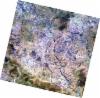
AL1_OPER_AV2_OBS_11_20080828T091147_20080828T091157_013818_0276_3900_0000
Download Product | Browse
wrsLongitudeGrid | 276 |
wrsLatitudeGrid | 3900 |
beginAcquisition | 2008-08-28T09:11:47.479Z |
endAcquisition | 2008-08-28T09:11:57.839Z |
productType | AV2_OBS_11 |
instrumentShortName | AVNIR-2 |
operationalMode | OBS |
orbitNumber | 13818 |
orbitDirection | DESCENDING |
sceneCentre | -14.935 16.620 |
acquisitionStation | SGS |
cloudCoverPercentage | 0 |
sceneId | AV2A138183900 |