
Static Map Catalogue - Product List
back to previous node |
list of download URLs
Collection ALOS_Africa_AVNIR2
ALOS AVNIR-2 African Coverage ESA archive. More information can be found on this page.
List of available products (latitude from 21.6704 to 22.5667 dg, longitude from -17.0063 to -16.0438 dg)..
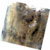
AL1_OPER_AV2_OBS_11_20070112T114720_20070112T114730_005155_0352_3160_0000
Download Product | Browse
wrsLongitudeGrid | 352 |
wrsLatitudeGrid | 3160 |
beginAcquisition | 2007-01-12T11:47:20.385Z |
endAcquisition | 2007-01-12T11:47:30.745Z |
productType | AV2_OBS_11 |
instrumentShortName | AVNIR-2 |
operationalMode | OBS |
orbitNumber | 5155 |
orbitDirection | DESCENDING |
sceneCentre | 21.901 -16.138 |
acquisitionStation | SGS |
cloudCoverPercentage | 1 |
sceneId | AV2A051553160 |
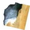
AL1_OPER_AV2_OBS_11_20070801T114924_20070801T114935_008087_0353_3150_0000
Download Product | Browse
wrsLongitudeGrid | 353 |
wrsLatitudeGrid | 3150 |
beginAcquisition | 2007-08-01T11:49:24.950Z |
endAcquisition | 2007-08-01T11:49:35.310Z |
productType | AV2_OBS_11 |
instrumentShortName | AVNIR-2 |
operationalMode | OBS |
orbitNumber | 8087 |
orbitDirection | DESCENDING |
sceneCentre | 22.398 -16.545 |
acquisitionStation | SGS |
cloudCoverPercentage | 2 |
sceneId | AV2A080873150 |
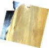
AL1_OPER_AV2_OBS_11_20070801T114933_20070801T114943_008087_0353_3160_0000
Download Product | Browse
wrsLongitudeGrid | 353 |
wrsLatitudeGrid | 3160 |
beginAcquisition | 2007-08-01T11:49:33.168Z |
endAcquisition | 2007-08-01T11:49:43.528Z |
productType | AV2_OBS_11 |
instrumentShortName | AVNIR-2 |
operationalMode | OBS |
orbitNumber | 8087 |
orbitDirection | DESCENDING |
sceneCentre | 21.902 -16.662 |
acquisitionStation | SGS |
cloudCoverPercentage | 2 |
sceneId | AV2A080873160 |