
Static Map Catalogue - Product List
back to previous node |
list of download URLs
Collection ALOS_Africa_AVNIR2
ALOS AVNIR-2 African Coverage ESA archive. More information can be found on this page.
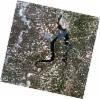
List of available products (latitude from 10.7815 to 11.6778 dg, longitude from -8.37083 to -7.3625 dg)..
AL1_OPER_AV2_OBS_11_20080531T110614_20080531T110624_012521_0333_3370_0000
Download Product | Browse
wrsLongitudeGrid | 333 |
wrsLatitudeGrid | 3370 |
beginAcquisition | 2008-05-31T11:06:14.524Z |
endAcquisition | 2008-05-31T11:06:24.884Z |
productType | AV2_OBS_11 |
instrumentShortName | AVNIR-2 |
operationalMode | OBS |
orbitNumber | 12521 |
orbitDirection | DESCENDING |
sceneCentre | 11.461 -8.294 |
acquisitionStation | SGS |
cloudCoverPercentage | 0 |
sceneId | AV2A125213370 |