
Static Map Catalogue - Product List
back to previous node |
list of download URLs
Collection ALOS_Africa_AVNIR2
ALOS AVNIR-2 African Coverage ESA archive. More information can be found on this page.
List of available products (latitude from -10.7815 to -9.88519 dg, longitude from 27.8625 to 28.8708 dg)..
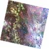
AL1_OPER_AV2_OBS_11_20061007T083117_20061007T083128_003738_0257_3800_0000
Download Product | Browse
wrsLongitudeGrid | 257 |
wrsLatitudeGrid | 3800 |
beginAcquisition | 2006-10-07T08:31:17.664Z |
endAcquisition | 2006-10-07T08:31:28.024Z |
productType | AV2_OBS_11 |
instrumentShortName | AVNIR-2 |
operationalMode | OBS |
orbitNumber | 3738 |
orbitDirection | DESCENDING |
sceneCentre | -9.958 27.923 |
acquisitionStation | SGS |
cloudCoverPercentage | 0 |
sceneId | AV2A037383800 |
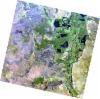
AL1_OPER_AV2_OBS_11_20070808T083008_20070808T083018_008187_0256_3800_0000
Download Product | Browse
wrsLongitudeGrid | 256 |
wrsLatitudeGrid | 3800 |
beginAcquisition | 2007-08-08T08:30:08.182Z |
endAcquisition | 2007-08-08T08:30:18.542Z |
productType | AV2_OBS_11 |
instrumentShortName | AVNIR-2 |
operationalMode | OBS |
orbitNumber | 8187 |
orbitDirection | DESCENDING |
sceneCentre | -9.959 28.460 |
acquisitionStation | SGS |
cloudCoverPercentage | 0 |
sceneId | AV2A081873800 |